VENEZUELA · COUNTRY GUIDE
Key Facts
- —What it is Venezuela is a federal republic of 23 states, a Capital District and Federal Dependencies on South America’s northern Caribbean edge.
- —Why it matters Venezuela holds the world’s largest proven crude-oil reserves and sits on Caribbean shipping routes linking South America with the eastern Caribbean.
- —The numbers The National Statistics Institute gives Venezuela’s territorial area as 916,445 square kilometres, with land borders shared with Colombia, Brazil and Guyana.
- —The catch Population estimates vary widely, from roughly 28.5 million to more than 34 million, reflecting divergent census bases and migration assumptions.
- —What it means for you A foreigner needs to understand Venezuela’s geography to assess travel access, business logistics, climate risk and regional connections before any commitment.
Where is Venezuela? It is the northernmost country of mainland South America, fronting the Caribbean Sea and Atlantic Ocean. Its position between Colombia, Brazil and Guyana shapes its trade, energy and migration links.
Venezuela is a country of dramatic geographic contrasts: Andean peaks, tropical grasslands, a vast river system and Caribbean islands. This guide explains the physical setting, the regions, the cities, the economy and what a foreigner should know before engaging with the country.
Where Venezuela Sits on the Map
Venezuela occupies the northern extreme of South America, between approximately 1° and 12° north latitude and 60° and 73° west longitude. The Caribbean Sea lies to the north, while the Atlantic Ocean touches the country’s northeastern coast. This location places Venezuela close to Caribbean islands and to maritime routes that connect South America with the eastern Caribbean.
The country shares land borders with three nations. Colombia runs along the west and southwest. Brazil lies to the south. Guyana sits to the east. These borders are not merely lines on a map; they define trade corridors, migration routes and long-standing territorial questions, particularly with Guyana.
Venezuela also includes numerous Caribbean islands, islets and cays. The most important offshore territories are Margarita Island, Coche, Cubagua and the Los Roques Archipelago. Margarita Island is a significant domestic tourism destination, while Los Roques is known for its coral reefs and clear waters.
The Venezuelan government’s National Statistics Institute describes the country as being in the northern extreme of South America and the Caribbean region. It gives Venezuela’s territorial area as 916,445 square kilometres. That makes Venezuela roughly twice the size of Sweden and larger than Turkey.
The Physical Regions of Venezuela
Venezuela is commonly divided into several major physical regions. Each has a distinct climate, economy and set of practical realities for anyone travelling or doing business there.
The Caribbean coast and northern ranges
The northern edge of the country contains coastal plains, dry zones, beaches and mountain systems. The Cordillera de la Costa runs along much of the central-northern coast, separating Caracas and other population centres from the Caribbean. Caracas lies in a mountain valley near the coast. Its elevation and surrounding mountains produce a milder climate than the hot lowlands, although the metropolitan area remains vulnerable to landslides, flooding and transport disruption during heavy rainfall.
The Andes and western highlands
The Venezuelan Andes occupy the west and northwest, especially the states of Mérida, Táchira and Trujillo. This region contains the country’s highest elevations, cooler climates, agricultural valleys and popular mountain destinations. Pico Bolívar is Venezuela’s highest mountain. Sources differ slightly over its precise elevation, generally placing it at about 4,978 to 4,981 metres above sea level.
The western highlands are important for coffee and other highland agriculture, tourism, cross-border trade with Colombia, mountain ecosystems, and hydropower and watershed protection. The Andean cities of Mérida and San Cristóbal have long been centres of education, commerce and regional identity.
Lake Maracaibo and the Maracaibo basin
Lake Maracaibo dominates northwestern Venezuela. It is connected to the Caribbean through the Gulf of Venezuela and supports one of the country’s most important petroleum-producing regions. The lake basin includes the state of Zulia, whose capital, Maracaibo, is one of Venezuela’s largest cities. The region has historically been central to the oil industry, but it has also faced infrastructure deterioration, power shortages, water problems and environmental pressure.
The Llanos
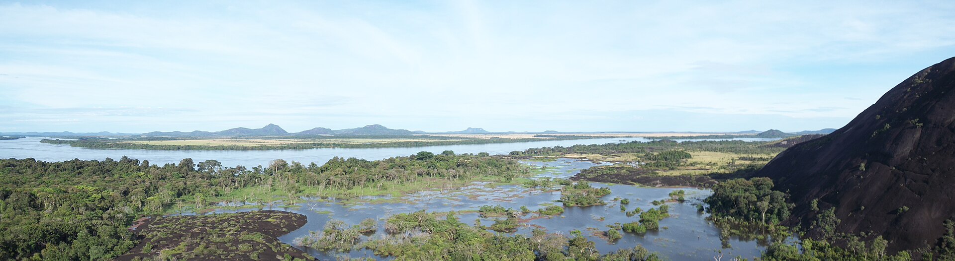
The Llanos are extensive tropical grasslands stretching across central Venezuela and continuing into Colombia. They are drained primarily by the Orinoco system and support cattle ranching, agriculture, wildlife and seasonal wetlands. The landscape changes markedly during the year. In the rainy season, large areas may become flooded. In the dry season, grasslands become drier and more suitable for cattle movement and transport. Roads and rural access can be difficult outside major corridors. For investors and businesses, the Llanos are relevant to agriculture, food supply chains, livestock, logistics and energy infrastructure.
The Orinoco River basin
The Orinoco is Venezuela’s principal river system and one of South America’s great rivers. It flows eastward across the country before reaching the Atlantic through a large delta. The river basin links the Llanos, Guiana Highlands, wetlands, forests, mining areas and industrial zones. The Orinoco’s lower reaches are especially important for river transport, biodiversity and access to eastern Venezuela.
The Guiana Highlands
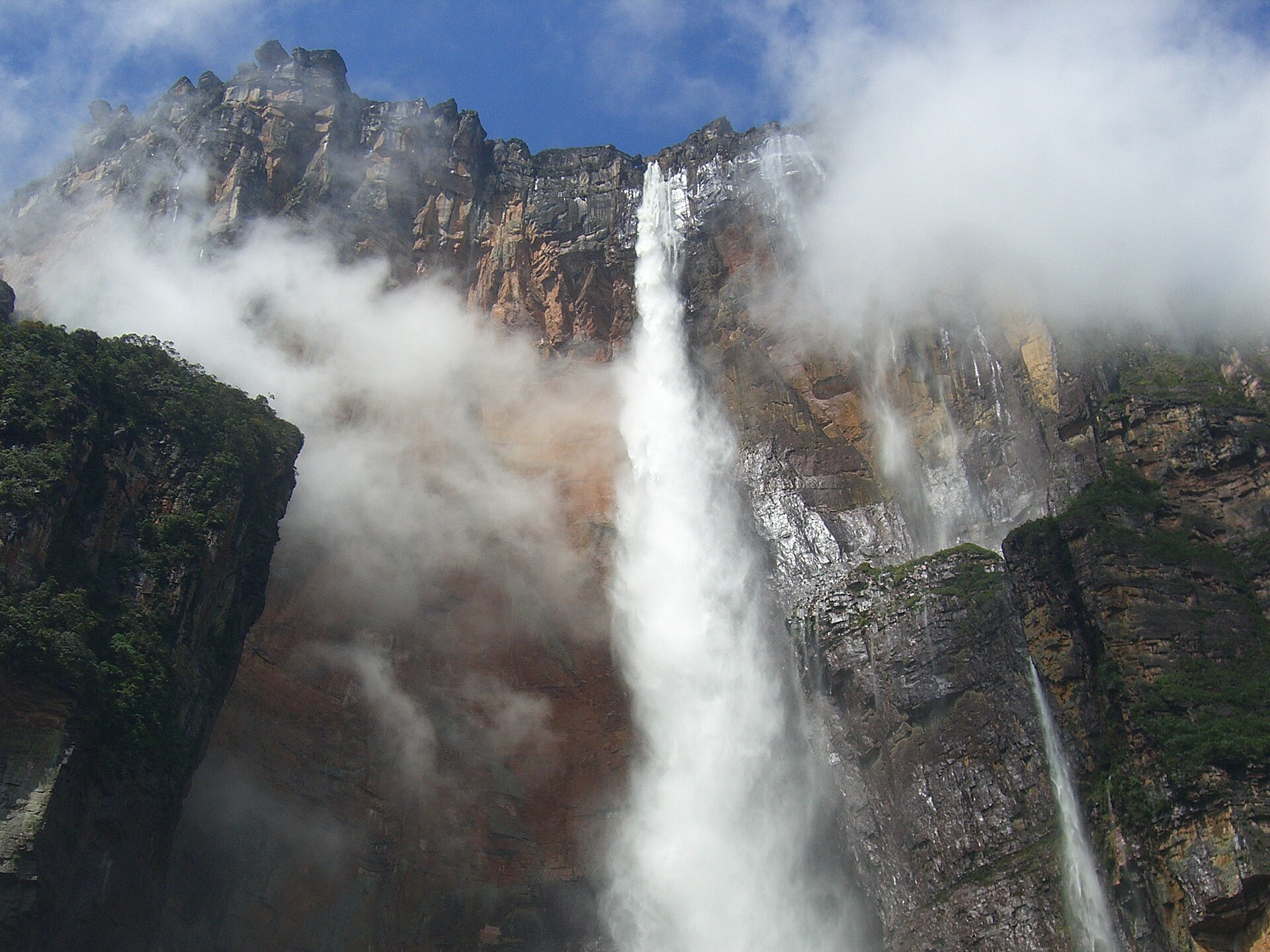
Southern and southeastern Venezuela form part of the ancient Guiana Shield, one of the world’s oldest geological formations. The region contains dense forests, major rivers, mineral deposits and flat-topped mountains known as tepuis. The most internationally recognized attraction is Angel Falls, located in Canaima National Park. It is widely identified as the world’s highest uninterrupted waterfall. Access generally involves a combination of air travel, river transport and guided excursions, and conditions can vary by season.
The Guiana Highlands are also associated with Canaima National Park, Mount Roraima, Indigenous communities, gold and other mineral extraction, hydroelectric generation and sensitive rainforest ecosystems. This region is remote and requires careful planning for any visit or commercial activity.
Climate: What to Expect by Region
Venezuela is tropical, but altitude and terrain create substantial regional variation. Coastal lowlands are generally hot, with seasonal rainfall. Caracas and the northern highlands are milder because of elevation. The Andes are cooler, with mountain climates. The Llanos have pronounced wet and dry seasons. The southern rainforest is hot and humid, with heavy rainfall. The arid northwest has drier conditions around parts of the Falcón and Zulia regions.
The best time to visit depends on the destination. Dry-season travel may improve access to some parks and rural areas, while the rainy season can produce stronger river flows and better conditions for viewing certain waterfalls. Travellers should check local transport and park access before departure, because conditions can change quickly and infrastructure may not be reliable.
Major Cities and What They Do
Venezuela’s population is concentrated in the north and west. The main urban centres are Caracas and its metropolitan area, the central coast, Maracaibo and western Zulia, Valencia and Maracay, Barquisimeto and the Andean cities.
Caracas is the national capital, political centre and largest metropolitan area. It hosts government institutions, financial services, universities, media organizations, hospitals and the country’s main concentration of corporate headquarters. The city is separated from the Caribbean coast by the Waraira Repano mountain range, historically known as El Ávila. Caracas has a relatively mild climate for a tropical city because of its elevation.
Maracaibo is the principal city of Zulia and the economic centre of the Lake Maracaibo basin. It has long been associated with petroleum, commerce and cross-border economic links with Colombia. Valencia, in Carabobo state, is one of Venezuela’s main industrial and manufacturing centres. Its location near the central highway network and Lake Valencia has made it strategically important for domestic distribution.
Barquisimeto, capital of Lara state, is a major commercial, agricultural and transport centre in western-central Venezuela. The surrounding region is known for agriculture, livestock, food processing and dry tropical landscapes. Ciudad Guayana, formed principally by Puerto Ordaz and San Félix, is located on the Orinoco near the Caroní River. It is associated with steel, aluminium, electricity generation, mining and heavy industry. Puerto La Cruz and Barcelona, neighbouring urban areas in Anzoátegui state, are important for petroleum, ports, tourism and access to northeastern coastal destinations.

Government, Population and Language
Venezuela has 23 states, the Capital District and the Federal Dependencies, which include offshore islands and other territories. The constitutional system is formally a federal presidential republic with executive, legislative and judicial branches. In practice, political power has been highly concentrated in the executive, and the country’s institutions and elections remain the subject of sustained international dispute. The National Assembly is the unicameral legislature. Caracas is the seat of the national government.
Spanish is the official and dominant language. Venezuela is also home to Indigenous peoples whose communities maintain their own languages and cultural traditions, particularly in southern and eastern regions. Large-scale migration has changed Venezuela’s demographic and economic profile. Millions of Venezuelans live elsewhere in Latin America, North America and Europe, while return migration and cross-border family networks continue to influence domestic consumption, remittances and labour markets.
Population figures vary substantially by source and methodology. Recent estimates range from approximately 28.5 million to more than 34 million. The difference reflects divergent census bases, migration assumptions and international estimates. Any serious analysis should identify the source and reference year rather than present a single figure without qualification.
The Economy: Oil, Mining and Beyond
Venezuela has the world’s largest proven crude-oil reserves according to widely cited international energy statistics, although production capacity and actual output have been constrained by sanctions, underinvestment, infrastructure deterioration, operational problems and political risk. The principal economic sectors include oil and gas, mining, electricity and hydropower, agriculture and livestock, food processing, manufacturing, retail and services, telecommunications and tourism.
The Orinoco Oil Belt, or Faja Petrolífera del Orinoco, contains extensive extra-heavy crude resources. Other historic production areas include the Lake Maracaibo basin and eastern Venezuela. The state oil company Petróleos de Venezuela, S.A. (PDVSA) remains central to the sector. Foreign participation has been affected by licensing arrangements, sanctions, joint ventures, contract uncertainty and the condition of pipelines, refineries and export infrastructure.
Venezuela has significant deposits of gold, iron ore, bauxite and other minerals. Mining activity is concentrated in the south and is economically important but associated with environmental damage, informal extraction, labour abuses, mercury contamination and security risks. The Guri hydroelectric complex on the Caroní River is a core component of Venezuela’s electricity system. Hydropower has historically supplied much of national generation, but drought, maintenance problems and transmission failures have contributed to power instability.
Important agricultural products include maize, rice, sugar, coffee, cocoa and livestock. Agriculture matters for domestic food supply and for regional trade, but the sector faces challenges from input shortages, infrastructure gaps and climate variability.
What This Means for Foreigners, Investors and Expats
For a foreigner, understanding where Venezuela is means understanding access. The country’s Caribbean coast offers maritime connections, but internal transport can be difficult. The Andes and the Guiana Highlands are beautiful but remote. The Llanos and the Orinoco basin are economically important but require local knowledge to navigate safely and efficiently.
Investors should look at geography as a risk and an opportunity. Oil and gas remain central, but infrastructure condition, sanctions and contract uncertainty shape every deal. Mining offers potential in the south, but environmental and security concerns are real. Agriculture and food processing have domestic demand, but logistics and input access are persistent constraints.
Expats and long-term visitors need to think about climate, altitude and urban infrastructure. Caracas offers services and a milder climate, but it is vulnerable to landslides and flooding. Maracaibo is hot and tied to the oil economy. The Andean cities are cooler and more agricultural. Each region has a different risk profile for health, transport and daily life.
The political situation remains contested. Because the available sources conflict over the presidency as of 2026, any foreigner should verify current officeholders through official Venezuelan records before making decisions. The same caution applies to economic data, which can vary by source and methodology.
What to Watch
Several geographic and economic factors deserve attention. The condition of the Guri hydroelectric complex affects electricity supply across the country. The Orinoco Oil Belt’s production levels shape export revenue and foreign participation. Mining expansion in the Guiana Highlands raises environmental and security questions. Cross-border dynamics with Colombia and Guyana influence trade, migration and territorial disputes.
Climate variability matters too. Drought affects hydropower and agriculture. Heavy rainfall triggers landslides in Caracas and flooding in the Llanos. Anyone with long-term interests in Venezuela should monitor these patterns, because they affect infrastructure, supply chains and daily life.
Finally, watch the data. Population estimates, oil production figures and economic indicators vary widely by source. A careful reader should always ask which institution produced a number, for which year, and under what assumptions. That discipline is essential for understanding a country as complex as Venezuela.
Related reading: Venezuela Neighbours Explained, Andes to the Caribbean; Who Is Nicolás Maduro? Venezuela's Deposed Leader and His 2027 US Trial Explained; Healthcare in Venezuela for Expats: Clinics, Insurance and the Private Option; more from Venezuela.
Frequently Asked Questions
Where is Venezuela located?
Venezuela is in northern South America, on the Caribbean coast. It borders Colombia to the west and southwest, Brazil to the south, and Guyana to the east, with the Caribbean Sea and Atlantic Ocean to the north and northeast.
What is the capital of Venezuela?
The capital and largest urban agglomeration is Caracas. It lies in a mountain valley near the Caribbean coast, separated from the sea by the Waraira Repano mountain range.
How big is Venezuela?
The Venezuelan government’s National Statistics Institute gives the country’s territorial area as 916,445 square kilometres. This includes the mainland and offshore islands such as Margarita Island and the Los Roques Archipelago.
What are the main geographic regions of Venezuela?
Venezuela is commonly divided into the Caribbean coast and northern ranges, the Andes and western highlands, the Lake Maracaibo basin, the Llanos grasslands, the Orinoco River basin and the Guiana Highlands.
What is the highest point in Venezuela?
Pico Bolívar, in the Mérida Andes, is Venezuela’s highest mountain. Sources generally place its elevation at about 4,978 to 4,981 metres above sea level.
What is Venezuela’s most famous natural landmark?
Angel Falls, located in Canaima National Park in the Guiana Highlands, is widely identified as the world’s highest uninterrupted waterfall. Access typically involves air travel, river transport and guided excursions.
What language is spoken in Venezuela?
Spanish is the official and dominant language. Indigenous communities, particularly in southern and eastern regions, also maintain their own languages and cultural traditions.
Sources: riotimesonline.com, riotimesonline.com, britannica.com, vajiramandravi.com, visionias.in, scmp.com. Retrieved 3 October 2026.
This article was produced by The Rio Times’ automated newsroom system. How we use AI · Report an error · Editorial responsibility: Matthias Camenzind, Editor-in-Chief
Fresh reporting on this topic, refreshed automatically as new stories are published.
- Oct 4Venezuela Oil Deal: US House Democrats Give Rubio Until 14 October
- Oct 4Chile Police Dismantle Synthetic Drug Lab in Santiago’s Ñuñoa District
- Oct 4Brazil Election Draws World Attention, With Trump Watching Closely
- Oct 4Venezuela Inflation Slows to 8.4% in September
- Oct 4Ecuador Electoral Court Fines Two Amigo Movement Leaders US$9,200 Each
- Oct 3Puerto Rico Lifts Official Coffee Price Minimums by 20%
- Oct 3Suriname Sends Second Rice Aid Shipment to Venezuela
- Oct 3Rory Branker Acquitted in Venezuela Terrorism Case