Guatemala Ayarza Swarm Logs at Least 180 Quakes

ENVIRONMENT · GUATEMALA
Key Facts
- —The country Guatemala lies where three tectonic plates meet, and small quakes are routine. Laguna de Ayarza is a volcanic crater lake in Santa Rosa department, in the south-east.
- —What happened Insivumeh, the national seismology institute, said on 2 October 2026 that at least 180 quakes struck near the lagoon in September. The largest, magnitude 4.1, hit on 30 September.
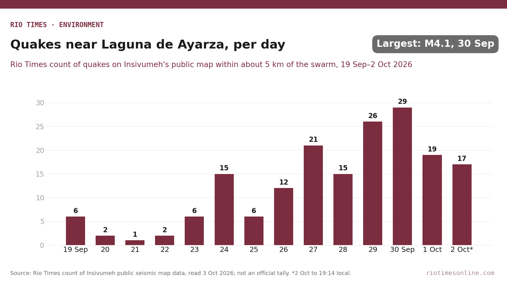
- —The numbers Only three were felt: magnitude 3.4 on 19 September, then 4.1 and 3.0 on 30 September. A Rio Times count of Insivumeh’s public map finds 19 quakes on 1 October and 17 on 2 October.
- —What it means for you Insivumeh calls the sequence normal for the area. The strongest shaking reached intensity IV, felt as light, though residents of nearby Pinos Altos report cracked walls.
- —Still open The swarm’s exact source and duration. Insivumeh plans a field visit to install sensors, and has drawn no link between the quakes and bubbles seen in the lagoon.
The Ayarza seismic swarm in south-eastern Guatemala reached at least 180 quakes in September, the national seismology institute said on Friday. Its report, published on 2 October, puts the largest at magnitude 4.1.
The institute says the sequence fits the area’s history and lies within normal parameters. It also says more quakes cannot be ruled out, and its public map shows they had not stopped by Friday evening.
What the seismology institute reported
Insivumeh, the National Institute of Seismology, Volcanology, Meteorology and Hydrology, places the epicentres about 2 kilometres south of Laguna de Ayarza. They lie in Casillas municipality, close to the border with Jutiapa department.
Activity stayed low for most of September. The rate rose after a magnitude 3.4 quake at 08:15 on 19 September, the institute said.
At 08:24 on 30 September a magnitude 4.1 quake struck, the largest so far, followed by a 3.0 at 08:43. These three are the only quakes residents reported feeling, though others may also have been noticed.
The quakes are shallow and linked to normal faults, where the crust is being pulled apart. La Hora, a Guatemala City daily, reported the same figures on 2 October.
Still active on 1 and 2 October
Luis Alejandro Argueta Cermeño, Insivumeh’s south-east coordinator, told Prensa Libre of 32 quakes in the 24 hours to 07:00 on 1 October. Two of them were felt, the 4.1 and the 3.0.
A Rio Times count of Insivumeh’s public seismic map, read early on 3 October, finds 19 quakes within about 5 kilometres of the swarm on 1 October. It finds 17 on 2 October, up to the map’s latest entry at 19:14 local time.
None of those exceeded magnitude 2.5, well below the 30 September peak. The daily counts come from the map’s entries and are not an official Insivumeh tally.
Cracks in Pinos Altos, bubbles in the lagoon
In the hamlet of Pinos Altos, near the epicentres, residents told Prensa Libre of underground rumbling, cracked walls and frightened schoolchildren. A teacher showed new cracks in classrooms at the village school, which about 80 children attend.
Many homes there are built of adobe and are damp from the rains. These damage reports come from residents, and no official damage assessment has been published.
Separately, videos of bubbles rising in the lagoon spread on social media in late September. The environment ministry (MARN) said gas can escape through cracks in the floor of the volcanic caldera.
An inspection with Insivumeh and Conred, the national disaster agency, found no sign of boiling water, Prensa Libre reported on 1 October. Insivumeh’s report draws no link between the quakes and the bubbles.
Why the institute is not alarmed
Santa Rosa has a history of swarm-type sequences of shallow quakes, the report notes. The 4.1 quake produced a top intensity of IV on the Modified Mercalli scale, meaning light shaking.
That peak was felt near the point where Santa Rosa, Jutiapa and Jalapa departments meet. The institute urges people to stay calm and to rely only on official channels from Insivumeh and Conred.
It says it will keep issuing synopses and special bulletins as the sequence evolves. The same institute monitors the country’s volcanoes, as in Guatemala’s Volcán De Fuego Eruption Forces Evacuations.
Shallow swarms are not unusual in the region. Colombia saw a comparable episode in late September, covered in Tolima Seismic Swarm: M4.5 Tremor Shakes Central Colombia.
What Is Not Yet Known
Insivumeh has not established the swarm’s precise source, and its analysis is still under way. Geologists and geophysicists are due to visit and install sensors, with no date announced.
Nobody can yet say how long the Ayarza seismic swarm will last or whether stronger quakes will follow. The institute says only that further quakes in the epicentral area cannot be ruled out.
Where is Laguna de Ayarza?
It is a volcanic crater lake in Santa Rosa department, in south-eastern Guatemala. The quakes are centred about 2 kilometres south of it, in Casillas municipality, near the border with Jutiapa.
Is the Ayarza seismic swarm dangerous?
Insivumeh says the sequence is within normal parameters for the area. The strongest shaking so far reached intensity IV, felt as light, although residents of nearby Pinos Altos report cracked walls.
Are the quakes making the lagoon boil?
No. An inspection by Insivumeh, Conred and the environment ministry found no evidence of boiling. Officials say bubbles can come from gas escaping through cracks in the lake floor.
Sources: Insivumeh, synopsis INS-DG-SS-SI-2026-04, seismic activity in Casillas, Santa Rosa, 2 October 2026; Insivumeh, public seismic map, read 3 October 2026; La Hora, “Laguna de Ayarza: Insivumeh registra más de 180 sismos en la zona”, 2 October 2026; Prensa Libre, Pinos Altos report and lagoon inspection report, 1 October 2026.
Editorial responsibility: Matthias Camenzind, Editor-in-Chief · Editorial standards · Report an error
Read More from The Rio Times