
SOUTH AFRICA · REGIONS
Key Facts
- —The basics South Africa is divided into nine provinces, each with its own elected legislature, premier and cabinet, drawn in 1994 to replace the apartheid map of four provinces and separate homelands.
- —Why it matters Provinces share responsibility for schools, hospitals, housing and public transport, so the province where an investor, student or retiree settles shapes the services, jobs and costs they meet.
- —The numbers As of mid-2026, Gauteng holds 16.3 million of 63.52 million people and produced 33.2% of 2024 GDP, about US$148 billion, while unemployment ranged from 19.5% in the Western Cape to 47.5% in the Eastern Cape.
- —Who is who The ANC holds seven premierships, including Panyaza Lesufi in Gauteng; the Democratic Alliance’s Alan Winde runs the Western Cape and the Inkatha Freedom Party’s Thami Ntuli runs KwaZulu-Natal.
- —What to watch Voters elect new municipal councils on Wednesday, 4 November 2026, including the eight metros such as Johannesburg, Cape Town and eThekwini, which covers Durban.
- —Prediction markets Polymarket gives a 77.3% chance that South Africa’s annual inflation for December 2026 ends above 5.0% (14 October, 11:54 a.m. ET).
- —What it means for you US investors deal mainly with Gauteng, travellers with the Western Cape, KwaZulu-Natal and Kruger, and anyone relocating should compare provinces, where unemployment differs by 28 points.
Nine provinces divide South Africa, but people, money and jobs are concentrated in a few of them. This guide explains each region as of October 2026.
South Africa regions are formally nine provinces, each with its own elected legislature, premier and cabinet. They were drawn in 1994, replacing the apartheid map of four provinces and separate homelands for black South Africans.
Where wealth, people and power sit has shifted little since then, and Gauteng, KwaZulu-Natal and the Western Cape dominate. For a US investor, student or visitor, the province often shapes schools, hospitals, roads and jobs.
Figures here come from Statistics South Africa (Stats SA), the national statistics office, and from government and electoral records. Conversions use the open.er-api.com rate of 14 October 2026, ZAR 16.49 per US$.
Daily news is in the Rio Times South Africa section. For the power structure behind the map, see South Africa politics explained and the guide to South Africa’s economy.
How South Africa Regions and Provinces Work
The 1996 Constitution names the nine provinces: Eastern Cape, Free State, Gauteng, KwaZulu-Natal, Limpopo, Mpumalanga, Northern Cape, North West and Western Cape. Each votes for a provincial legislature alongside the national election, most recently in May 2024.
The legislature elects a premier, who appoints an executive council of members known as MECs. Provinces share powers over school education, health services, housing, agriculture and public transport with the national government.
Provincial roads, ambulance services and liquor licences belong to the provinces alone. Most of their money comes as a share of national revenue, divided each year through the national budget.
Stats SA estimates the national population at 63.52 million in mid-2026. More than half, 36.3 million people, live in just three provinces: Gauteng, KwaZulu-Natal and the Western Cape.
Below the provinces sit 257 municipalities, which handle water, electricity distribution and refuse removal. Eight of them are big-city metropolitan municipalities, or metros, including Johannesburg, Cape Town and eThekwini, which covers Durban.
Party control differs from province to province, which makes the map political as well as administrative. The African National Congress (ANC), which has led the national government since 1994, holds seven of the nine premierships.
The pro-market Democratic Alliance (DA) runs the Western Cape under Premier Alan Winde. The Inkatha Freedom Party (IFP), whose base is among Zulu-speaking voters, leads KwaZulu-Natal under Premier Thami Ntuli.
The government’s leaders directory listed all nine premiers in office on 14 October 2026. Panyaza Lesufi of the ANC is premier of Gauteng, the richest province.
How the provinces came to be is covered in South Africa history explained. The sections below take the provinces one region at a time.
Gauteng, the Small Province That Runs the Economy
Gauteng covers just 18,178 square kilometres, making it the smallest province and smaller than New Jersey. Yet it is home to an estimated 16.3 million people, or 25.7% of the population, Stats SA estimates show.
The province produced 33.2% of national GDP in 2024, worth R2.44 trillion (about US$148 billion) at current prices. Finance, real estate and business services make up 27% of its economy, the largest single slice.
Johannesburg, the provincial capital, hosts the Johannesburg Stock Exchange, the largest securities exchange in Africa. Pretoria, in the same province, is the administrative capital and home of the Union Buildings.
Most overseas visitors enter South Africa through OR Tambo International Airport, east of Johannesburg. Gauteng is also the main magnet for migrants, with an estimated net gain of 794,991 people between 2021 and 2026.
That pull has not solved unemployment, which stood at 34.6% in the second quarter of 2026. The national rate was 33.6%, up from 32.7% in the first quarter, the Stats SA labour survey shows.
The Gauteng metros of Johannesburg, Tshwane and Ekurhuleni are among the biggest prizes in local elections. For daily life in the province, see the Johannesburg city guide.
KwaZulu-Natal, Ports, Mountains and a Kingdom
KwaZulu-Natal is the second most populous province, with an estimated 12.3 million people in 2026. It produced 16.1% of GDP in 2024, worth R1.18 trillion (about US$72 billion).
The port of Durban is one of the busiest in Africa, and Richards Bay is a major coal-export harbour. Together they make the province central to South Africa’s seaborne trade.
In the west, the uKhahlamba-Drakensberg Park gained World Heritage status in November 2000. Its basalt cliffs draw hikers, while the warm Indian Ocean coast draws beach holidays.
IsiZulu is the home language of 82.5% of residents, the 2022 census found. The government’s official guide notes that it is the only province whose monarchy the Constitution specifically provides for.
Unemployment in the province stood at 32.5% in mid-2026, slightly below the national rate. Personal services form the largest part of its economy, at 19% of output in 2024.
Durban sits in eThekwini, the province’s only metro. For life on the coast, see the Durban city guide.

Western Cape, the Province Run by the Opposition
The Western Cape has an estimated 7.7 million people and produced 14.2% of GDP in 2024. That output was worth R1.04 trillion (about US$63 billion), with finance and business services at 27%.
It had the lowest unemployment rate of any province in mid-2026, at 19.5%. Every other province was above 28%, and the national rate was 33.6%.
Cape Town is the legislative capital, where Parliament sits, and the province is the DA’s power base. It is the second biggest magnet for migrants, with an estimated net gain of 319,053 people between 2021 and 2026.
Afrikaans is the most common home language at 46.6%, ahead of isiXhosa at 31.1% and English at 19.6%. Table Mountain, the Cape winelands and Robben Island make it a favourite of foreign tourists.
Residents also live longest, with life expectancy at birth of 67.0 years for men and 72.8 for women over 2021 to 2026. The Cape Town city guide has practical advice for newcomers.
The Mining Belt, North West, Mpumalanga and Limpopo
Mining and quarrying are the largest industry in North West, at 24% of output, and in Mpumalanga, at 17%. The government’s official guide calls North West the Platinum Province for its platinum and chrome.
North West borders Botswana and is home to Sun City and the Pilanesberg National Park. Its capital is Mahikeng, and unemployment reached 38.1% in the second quarter of 2026.
Mpumalanga, whose name means place where the sun rises, has its capital at Mbombela. Steel and chrome-alloy plants operate on its northern Highveld, and unemployment stood at 36.3%.
Limpopo, the northernmost province, borders Mozambique, Zimbabwe and Botswana. It contains the largest section of the Kruger National Park, along its eastern edge.
Limpopo’s economy grew 0.9% in real terms in 2024, the fastest of any province. It also has the highest share of children under 15 of any province.
Yet many residents leave, with an estimated net loss of 152,540 people between 2021 and 2026. Its unemployment rate stood at 32.0% in mid-2026.
Northern Cape and Free State, Space, Diamonds and Gold
The Northern Cape covers 372,889 square kilometres, almost a third of the country and slightly smaller than Montana. Only about 1.4 million people live there, 2.2% of the population.
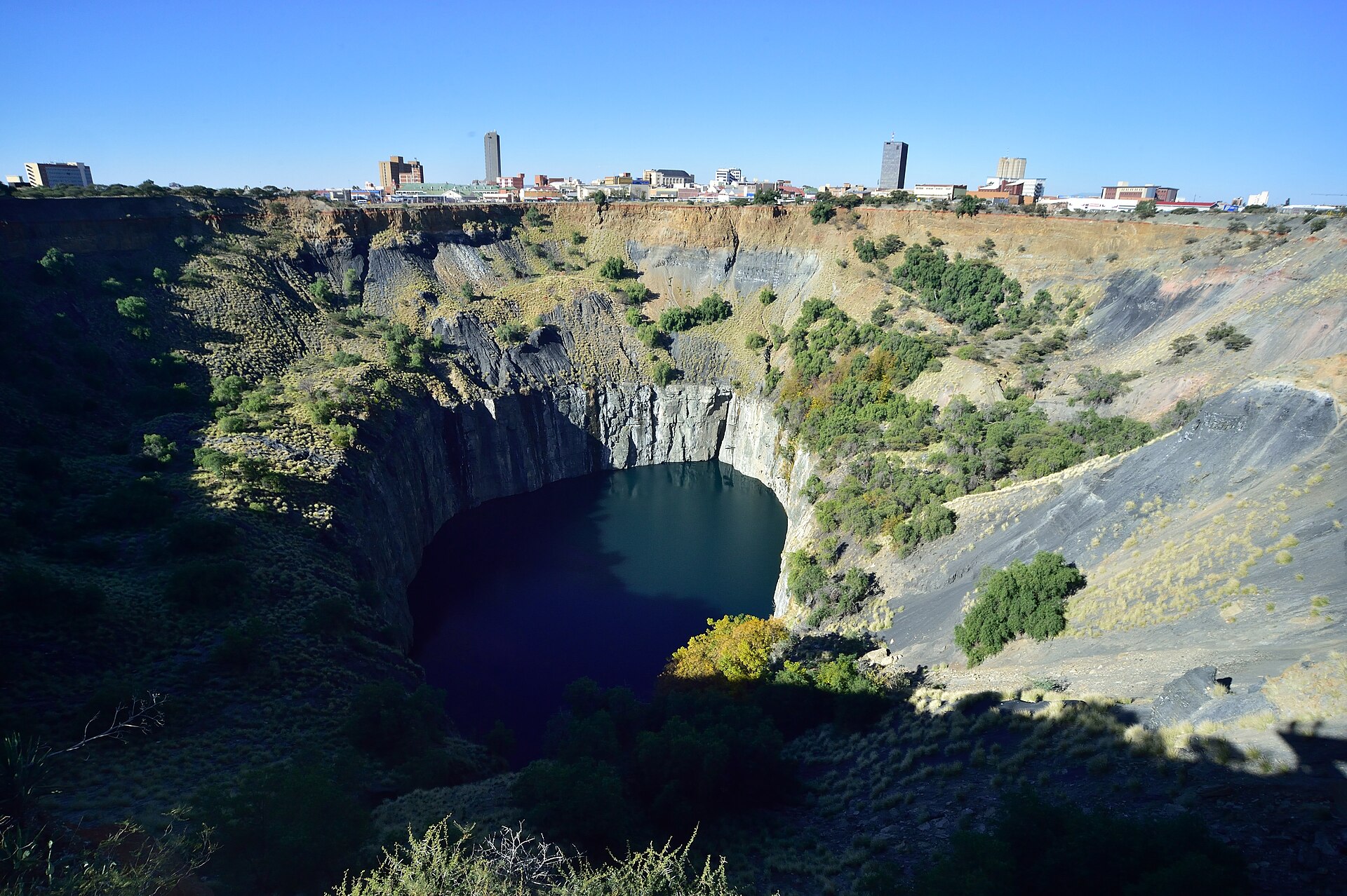
It produced just 2.2% of GDP in 2024, the smallest share, with mining as its largest industry at 17%. Its capital is Kimberley, and the province is known for diamond diggings, San rock art and the Kgalagadi Transfrontier Park.
The province also hosts the Southern African Large Telescope at Sutherland and part of the Square Kilometre Array radio telescope. Its unemployment rate, 28.7% in mid-2026, was the second lowest after the Western Cape.
The Free State, in the heart of the country, has about 3.1 million people and produced 5.0% of GDP in 2024. Mining, particularly gold, is its biggest employer, followed by manufacturing, the government’s guide says.
Bloemfontein, its capital, is the judicial capital and seat of the Supreme Court of Appeal. The province has the lowest life expectancy of the nine, and its unemployment rate was 37.3% in mid-2026.
Eastern Cape and the Divide Between Regions
The Eastern Cape shows the other side of the map. Its unemployment rate reached 47.5% in the second quarter of 2026, the highest of any province.
The province has an estimated 7.0 million people and the highest share of residents aged 60 or older. It also lost the most people to migration, a net 295,374 between 2021 and 2026.
Its economy shrank 0.2% in real terms in 2024, and personal services form its largest industry at 23%. The capital is Bhisho, while Gqeberha, formerly Port Elizabeth, and East London are its main cities.
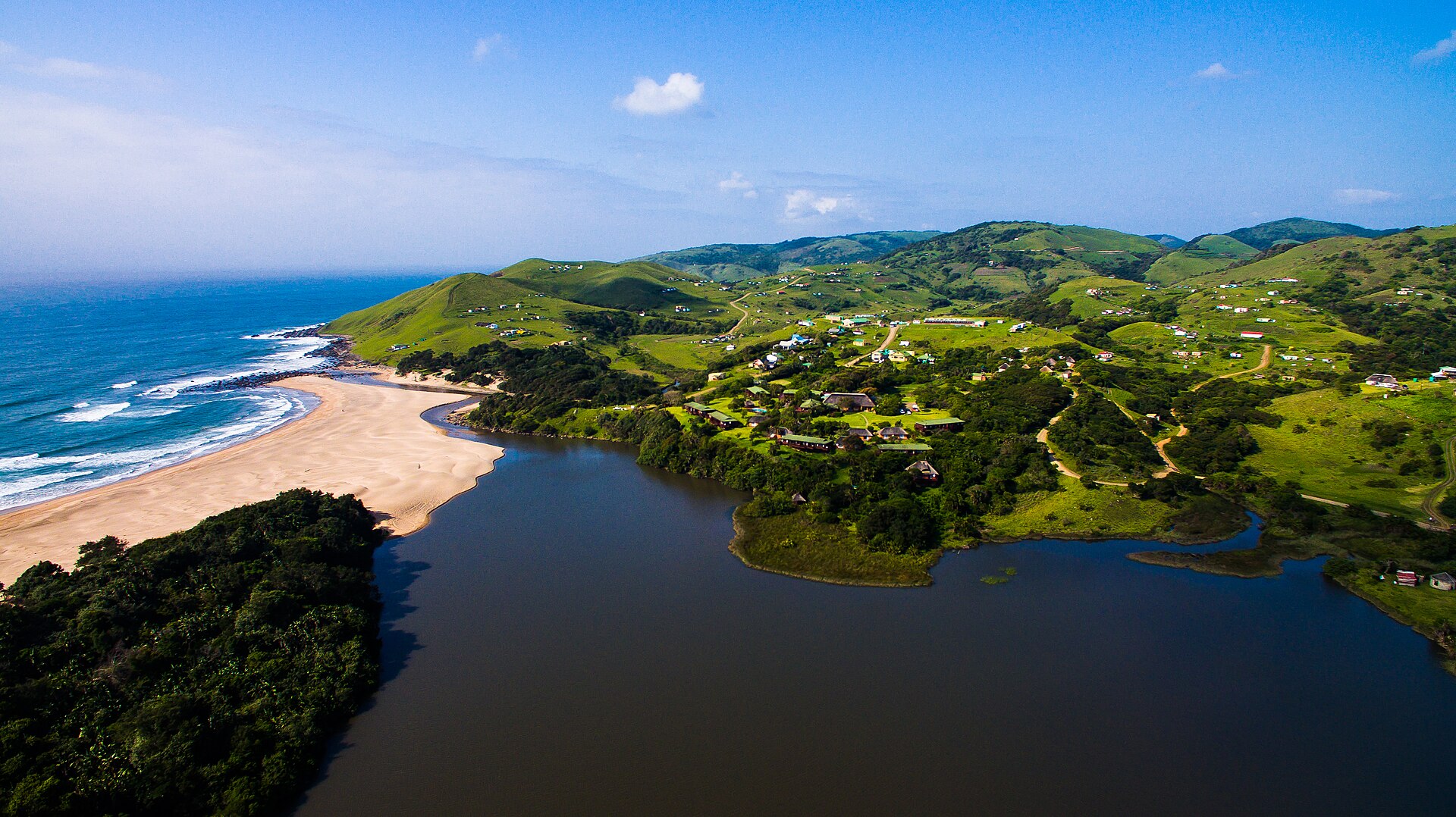
IsiXhosa is the home language of 82.7% of residents, and the rugged Wild Coast draws visitors. The gap with Gauteng and the Western Cape drives a steady flow of people towards those two provinces.
That flow adds pressure on housing, water and transport in the receiving cities. The sending provinces, led by the Eastern Cape and Limpopo, lose working-age residents to the economic core.
These gaps shape national politics, because all nine provinces draw on the same pool of national revenue. They will be tested again when voters elect new municipal councils on Wednesday, 4 November 2026.
On 14 October the Electoral Commission said the country had entered the last 21 days before the vote. The guide to the 2026 local elections explains the parties and the metros at stake.
What It Means for US Readers
For US investors, Gauteng is the centre of gravity, with the stock exchange and a third of national output. For travellers, the Western Cape, KwaZulu-Natal and the Kruger National Park are the main draws.
Platinum and chrome from North West feed global supply chains for car catalysts and stainless steel. Jobs in the mining belt therefore rise and fall with world metal prices.
For anyone relocating, the province matters as much as the city. Unemployment runs from 19.5% in the Western Cape to 47.5% in the Eastern Cape, and male life expectancy varies by eight years.
The 4 November local elections will decide who runs Johannesburg, Cape Town and the other metros. Those councils manage water, electricity distribution and building permits that residents and businesses rely on.
What Prediction Markets Say
Polymarket, a crypto-based prediction market, prices a 77.3% chance that South Africa’s annual inflation for December 2026 ends above 5.0%. It gives a further 13.4% to a reading between 4.7% and 5.0% (14 October, 11:54 a.m. ET).
The bets resolve on the Stats SA consumer price index for December 2026, due on Wednesday, 20 January 2027. Trading volume on the market totalled about US$92,300 by late morning on 14 October.
Stats SA put annual inflation at 4.4% in August 2026, up from 4.3% in July but below June’s 5.0%. Transport prices rose 8.8% over the year, and the September figure is due on Wednesday, 21 October 2026.
Why we show this: prediction markets turn real-money bets into a live probability that moves within minutes of the news, which is why investors, campaigns and newsrooms in the United States now follow them closely. We show them next to polls and official results, never instead of them.
What Is Not Known
The latest provincial GDP figures cover 2024, so the effect of 2025 and 2026 on each province is not yet measured. Population numbers for 2026 are Stats SA estimates, not census counts.
Whether inflation climbs back above 5.0%, as the bets suggest, will not be clear until later releases. The outcome of the 4 November municipal elections, and any new council coalitions, is unknown.
Third-quarter labour figures, due later in 2026, may change the provincial unemployment ranking. Whether migration to Gauteng and the Western Cape slows is also an open question.
Frequently Asked Questions
How many provinces does South Africa have?
South Africa has nine provinces, created in 1994 and named in the 1996 Constitution. Each has its own legislature, premier and executive council.
Which is the richest province in South Africa?
Gauteng is the largest economy, producing 33.2% of national GDP in 2024. KwaZulu-Natal followed with 16.1% and the Western Cape with 14.2%.
Which province has the lowest unemployment?
The Western Cape had the lowest rate in the second quarter of 2026, at 19.5%. The Eastern Cape had the highest, at 47.5%.
What are the three capitals of South Africa?
Pretoria is the administrative capital and Cape Town the legislative capital, where Parliament sits. Bloemfontein is the judicial capital, home to the Supreme Court of Appeal.
Which is the largest province by area?
The Northern Cape is the largest, covering almost a third of the country’s land. Gauteng is the smallest, yet it has the most people.
Who governs the Western Cape and KwaZulu-Natal?
The Democratic Alliance governs the Western Cape under Premier Alan Winde. KwaZulu-Natal is led by Premier Thami Ntuli of the Inkatha Freedom Party.
Sources: Stats SA, Mid-year population estimates 2026; Stats SA, Mbalo Brief August 2026 (labour survey Q2 2026); Stats SA, Consumer Price Index August 2026; Stats SA, Regional gross domestic product 2024; South African Government, South Africa’s provinces; South African Government, leaders directory; South African Government, History; South African Government, Local government; Constitution of the Republic of South Africa, 1996; Electoral Commission of South Africa; Parliamentary Monitoring Group, 2026 State of the Province Addresses; open.er-api.com exchange rates (all accessed 14 October 2026).
This article was produced by The Rio Times’ automated newsroom system. How we use AI · Report an error · Editorial responsibility: Matthias Camenzind, Editor-in-Chief
Part of our ongoing coverage
Africa: The New Scramble — the great-power contest over the continent.
Expat Guide to South Africa
What The Rio Times publishes for foreigners who live in or move to South Africa.
Start here
- South Africa Taxes for Expats 2026: What You Pay
- South Africa Remote Work Visa 2026: Rules and Income
- Moving to South Africa: Visa Route Decides Everything, 54,000 Applications Overdue at Home Affairs
- South Africa Residency Visa Requirements and How to Meet Them
City guides
Cape Town, Johannesburg, Durban
Coming up in South Africa
- What to Do in Cape Town in October 2026 14 Oct
- Mamma Mia Montecasino Season Opens 16 October in Johannesburg, South Africa 16 Oct
- South Africa Hosts 9,000 Energy Delegates in Cape Town, 12-16 October 16 Oct
- Ne-Yo Sells Out Cape Town and Pretoria for 17 and 18 October 17 Oct
Understand South Africa