RIO DE JANEIRO, BRAZIL – The volume of water in the main rivers that cut through the state of Amazonas continues to rise, affecting the population in some cities. In Parintins, the level of the Amazon River has exceeded the historical high water mark of 9.38 meters, registered in June 2009.
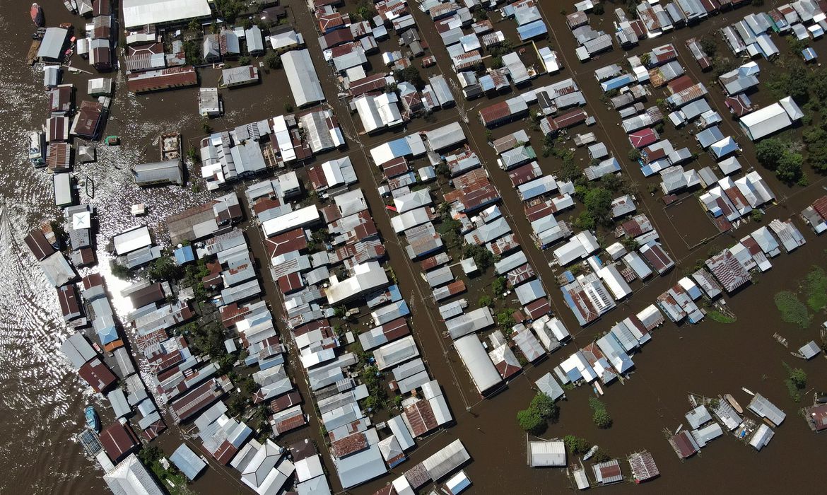
Yesterday, May 17, the Negro River reached a depth of 29.72 meters near Manaus, where the severe flood level of 29 meters was exceeded on April 30.
The severe flood level is the highest among the four monitoring marks established by the Brazilian Geological Service (CPRM), higher than the flood level, which is determined according to the height at which the water of a river begins to cause the first damage or setbacks.
In Parintins, in addition to flooding the city streets, the Amazon River overflow has led to farmers losing crops planted in floodplain areas. The city hall said it is helping the affected families, distributing basic food baskets and wood to build bridges and platforms that the inhabitants of flooded houses erect to suspend the floor above the water level.
However, last week the Mayor of Parintins, Bi Garcia, conceded that, due to the demand, he was struggling to acquire wood. “We are struggling greatly to buy wood. The city government can only buy legalized wood. We are going to prioritize the bridges and then seek help to build platforms in the houses flooded by the Amazon River,” Garcia said after visiting affected communities.
In Manaus, the mayoralty announced that it will use sand bags to build barricades downtown along Eduardo Ribeiro Avenue, in order to contain the water advancing due to the flooding of the Negro River.
According to the city hall, the mark reached yesterday morning, 29.72 meters, is behind only the 29.97 meters recorded in 2012, and 29.77 meters in 2009. Temporary bridges and footbridges are being built all over the city as a means to safeguard people’s mobility. On May 6, the city government declared a 90-day emergency situation in the city.
River levels
The situation tends to worsen in riverside cities. According to the Brazilian Geological Service, the river levels in virtually all river basins are high for this time of the year. In the Amazon Basin, for one, the volume of water should continue to rise due to the rainfall affecting the North Region. The same is true for the Negro River Basin. Experts estimate that, near Manaus, the river level may exceed the 30.35 meter mark.
“In probability terms, it is safe to assert that the level of the Negro River should reach between 29.50 and 30.50 meters. That is, depending on rainfall, there is a high probability of a flood as severe as the one in 2012, when the level reached 29.97 meters. We need to be prepared,” alerted researcher Luna Gripp Simões Alves in late April, when the Brazilian Geological Service released its second flood alert for the state.
At the same time, meteorologist Renato Senna from the Amazon Protection System’s Management and Operational Center (CENSIPAM) pointed to a trend toward increased rainfall, which had already been affecting the Rio Negro Basin and other regions.
“CENSIPAM is forecasting rainfall exceeding the climatology standards for the south of Roraima and the north and northwest of Amazonas, which will affect the behavior of the Negro, Japurá and Içá river basins, as well as the course of the Amazon and the Solimões river channel,” said Senna, explaining that this is due to the effects of La Niña climate phenomenon, during which the Pacific Ocean water temperature drops, causing changes in rainfall patterns.
Source: Agência Brasil