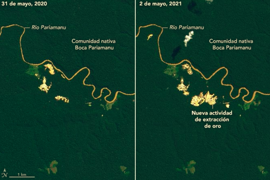
RIO DE JANEIRO, BRAZIL – From space, it penetrates the dense layer of clouds that dominates the rainforest, tracks illegal mining, and warns throughout the year of deforestation in the Peruvian Amazon. In this country, the “gold rush” has depredated more than 96,000 hectares of primary forests in the last 30 years.
It is RAMI, a brand new geospatial technology tool that monitors via satellite and radar the progress of gold mining in the jungle region of Madre de Dios, the biodiversity capital of Peru.
Read also: Check out our coverage on Peru.
There lies La Pampa, a territory located in the buffer zone of the Tambopata National Reserve, today buried in mercury, with huge wastelands, mud ponds, and nests of scrap metal for years the great bastion of illegal and informal mining in this region of the country.
In addition to generating early mining alerts and allowing access to real-time information on changes in forest cover, the novelty of this radar mining monitoring tool lies in its ability to overcome the limitation of clouds and observe forests regardless of weather phenomena 365 days a year.
“Before this new platform was incorporated, we worked only at the level of optical images, but there was a basic deficiency: the satellite captured images only six months a year, from June to December, because there was a vacuum of information during the rainy season,” explained to Efe, the specialist of the Satellite Georeferential Monitoring Unit of the Specialized Environmental Prosecutor’s Office (FEMA) of Madre de Dios.
The man, who preferred to remain anonymous for security reasons, added that now, with RAMI, “monitoring is constant, whether it is day or night, rain or clouds.”
CONSERVING FORESTS
The Amazon Conservation Association – ACCA developed this radar remote sensing tool under the SERVIR-Amazon program, led by the Bioversity International Alliance and the International Center for Tropical Agriculture (CIAT).
SERVIR-Amazon is part of SERVIR Global, a joint development initiative between the National Aeronautics and Space Administration (NASA) and the United States Agency for International Development (USAID).
The implementation of RAMI, since last June, seeks to strengthen the Peruvian Government’s actions to combat the loss of forest cover to illegal mining in Madre de Dios and thus contribute to the conservation of one of the most diverse rainforests on the planet.
Deforestation, loss of ecosystems, and contamination of water, sediments, and atmosphere are just some of the most direct impacts of the advance of this scourge, which makes indiscriminate use of machinery to cut down forests, dredges to suck up the soil and mercury to separate the precious metal.
This was summarized for Efe by the director of ACCA in Madre de Dios, Juan Loja, who insisted on the usefulness of the monthly alerts generated by RAMI not only for the government and the heads of protected areas but also for the native communities of the region, the Police and the Public Prosecutor’s Office.
FIELD OPERATIONS
“This information is essential because it supports what one can make known in one way or another. For example, if there is an invasion in the territory of a community, you can say so over the phone. Still, it is much better when there is photographic or video evidence. We look to see if it is a forestry issue or not and where we refer it to,” Julio Cusurichi, president of the Native Federation of the Madre de Dios River and its tributaries (FENAMAD), explained to Efe.
The provincial prosecutor of the Fifth Office of the FEMA of Madre de Dios expressed himself in the same sense: “These satellite images help us to determine where the mining activity is taking place,” and “with this information, we can agree on a plan with the Police to carry out an intervention,” the lawyer told Efe.
“Since the Peruvian government launched Operation Mercury in February 2019, an unprecedented measure to tackle illegal gold mining in La Pampa, prosecutors and police go out every day to the countryside to wipe new illegal mining camps off the map and seize or intervene machinery and vital inputs for this form of criminality.
“With RAMI, we hope to encourage this and other efforts that have not yet been able to reverse the environmental disaster caused by the illegal exploitation of one of the many treasures of the Peruvian jungle.”