RIO DE JANEIRO, BRAZIL – Brazil is drying up. Satellite image analyses of the Brazilian territory between 1985 and 2020 show that in only 35 years there is surface water loss in 8 of the 12 hydrographic regions, in all of the country’s biomes. Brazil lost 15.7% of its fresh water between 1991 and 2020.
The data are from MapBiomas researchers, an initiative involving NGOs, universities and technology companies. It is currently the platform with the most up-to-date database on land cover and land use transformations in Brazil.
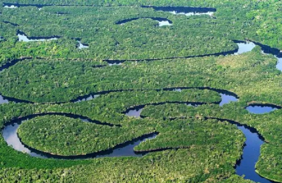
Now launched, MapBiomas Água maps the territorial dynamics of surface water across Brazil. Over 150,000 satellite images were processed over 36 years, between 1985 and 2020, to differentiate what is happening to natural water bodies (rivers, lakes, ponds) from man-made water bodies, such as hydroelectric reservoirs.
The country is currently experiencing a severe water crisis, an acute stage of the problem. The study points to a chronic scenario, which has worsened over the past 3 decades.
“Brazil is consistently losing surface water. Flood periods are no longer enough to offset drought periods,” says MapBiomas’ general coordinator Tasso Azevedo, a forestry engineer. “The water surface in Brazil is decreasing and it is no small thing.”
Brazil’s water-covered surface in 2020 totaled 16.6 million hectares, four times the size of the state of Rio de Janeiro. In 1991, it was 19.7 million hectares. The loss, of 3.1 million hectares in 30 years, corresponds to more than one and a half times the water surface of the entire Northeast region.
“We had no idea,” Azevedo says. The new platform is “an x-ray of where the water is located in Brazil.”
The state that lost the most water surface area was Mato Grosso do Sul, down 57%. This reduction occurred basically in the Pantanal. Mato Grosso is second, followed by Minas Gerais.
Brazil’s water loss is occurring for three main reasons, Azevedo says. The first is climate change, which is prolonging the dry periods and shortening the rainy seasons, and concentrating the rainfall. “It rains a lot, in a concentrated way, and the water drains and disappears,” he says. The second point is the Amazon deforestation, which reduces the “flying rivers,” also formed by the forest evapotranspiration. “It is worth noting that a third of Brazil’s rainfall comes from the Amazon,” he recalls.
The third aspect is what occurs locally, with deforestation and the conversion of areas in these regions, especially near rivers. “The native vegetation has a sponge effect. It takes in and absorbs rainwater and releases it little by little. But when the vegetation is removed, the water is no longer stored in the forests and soil. And this worsens with climate change,” Azevedo says.
The case of the São Francisco River, which flows through Cerrado (savannah) and Caatinga (semi-arid) areas, is well known. The data show that there is a decreasing trend in the water surface, particularly on the left bank where the agricultural boundary lies. “The reduction was noticed in the past 15 years, coinciding with the agricultural expansion period in Matopiba [a four-corner multi-state area],” says a note sent to the press on the MapBiomas Água platform.
The increased water consumption from agricultural activities added to the silting of the river channel, and dry periods typical of the region have resulted in a 10% water reduction in the past 15 years.
The Amazon’s Negro River is also suffering from a lower flow. It lost 22% of its water surface, mainly between 1999 and 2000. “In the case of the Amazon, in the arc of deforestation area, we notice a massive amount of small reservoirs on farms,” Azevedo says.
“These private dams take water from the natural course. Less water, less evapotranspiration from forest trees, which results in less rain, and more drought. And to fight drought, more private reservoirs,” he says.
There is a relationship between the municipalities registering most fires in the period and those losing the most water. Corumbá, in Mato Grosso do Sul, was the leader. Cáceres is the 5th municipality with the most fires in Brazil and the second among those that lost the most water surface area. “The cycles of fire and water are interconnected and feed each other,” says the forest engineer.
He explains: less water leaves the soil and the organic matter on the ground more vulnerable to fire. “More fire eliminates vegetation, which is key to protecting springs and rivers,” he continues.
There are specific dynamics, which the new platform clearly shows. In the Cerrado, natural water from rivers is losing space to man-made water surfaces, such as reservoirs. In the Atlantic Forest there are water loss issues due to the 2001 and 2015 water crises which have not been recuperated.
The loss of natural water surface area as a result of a greater number of man-made structures has an impact on biodiversity and river dynamics, the analysis points out.
Brazil is home to 12% of the planet’s freshwater reserves. There are 83 border and transboundary rivers, representing 53% of South America’s water resources.